
Trams and Trolleybuses in West Street, Erith
From: "John King" <JKing77189@aol.com>
|
|
| Click on picture [WSE] for an enlarged version |
|
|
| Click on picture [JK22] for an enlarged version |
|
|
| Click on picture [405] for an enlarged version |
|
|
| Click on picture [TR4] for an enlarged version |
|
|
| Click on picture [WSE2] for an enlarged version |
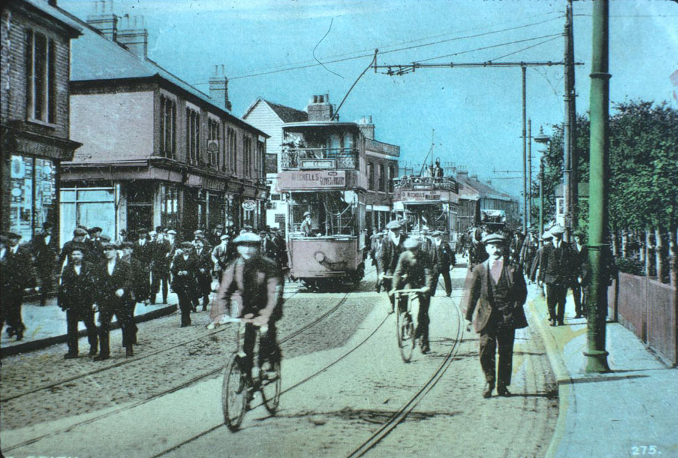
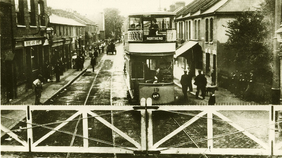
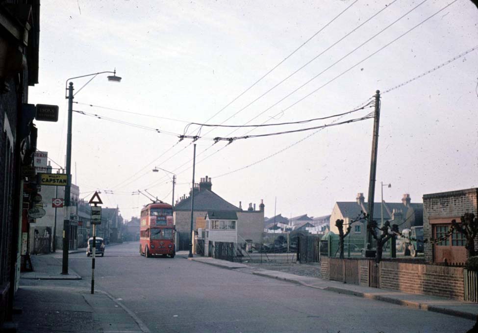
Picture WSE is West Street Erith. The same location as pictures JK22 and 405. It is about the same place as the
trolleybus. Behind the tram going to Abbey Wood is the pub in the pictures. If you look to the left of this tram you can see
the gap where the railway goes. Look at the ornate lamp on the pub and you will see if you look carefully the same lamp in
JK22. The little white hut to the right of the picture I think is where the man wound the gates shut and open.
Abbey Wood was the western terminus of the Erith tramways on this route. as no through running was agreed with the LCC.
You had to change trams here if you wanted to go to Woolwich.
It looks very busy in the picture either dinner time or knocking off time. There was lots of industry in the area. Not
far from here in a side street was the Erith Corporation restaurant, which was no doubt patronised by the workers.
It was called the Corinthian Restaurant. It closed down in the early 60s when municipal enterprise became
unfashionable.
The Erith Corporation trams went from Abbey Wood, Harrow Inn to at first Northumberland Heath on the Erith/Bexley border until through
working was agreed with Bexley to Bexleyheath Market Place. Through working from Abbey Wood to Woolwich was never agreed,
and a change to the LCC route was needed. The tram in the picture is showing North End which was a short branch off the route at Erith.
North End is nowadays around Slade Green on the Erith/Crayford border.
When LT took the routes over Erith became the 98 tram, and was converted to the 698 trolleybus, when at last through working from
Abbey Wood to Woolwich came about.
From: "HAZEL BREWER" <noisette@btinternet.com>
I moved into the Erith area in 1997 and have recently started work at Birch House off Birch walk
in Erith.
My other half, who is very much into narrow gauge railways, tells me that the industrial unit off Birch Walk is on
part of the site of the former Parishes Loam Quarry which had a 4 foot gauge system. However, the documentation we have
is very limited and I wonder if anyone who helped you create the trolleybus pages [which I found absolutely amazing] has
any photos, maps and literature on Parishes Loam Pit.
From: "John King" <JKing77189@aol.com>
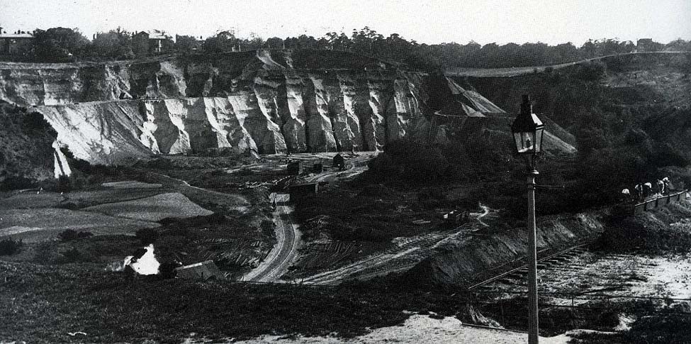
I lived alongside Parishe's Loam Quarry for the first 15 years of my life. [We called it The
sand pit]. I used to sit and watch the mechanical diggers in action at the cliff at the rear from my front room
window. However I don't remember taking any photographs of it. I suppose it was just part of every day life.
The only picture
I can find of Erith Loam Pit is found the book 'A View from the River' published by Bexley Libraries
and Museums Department in 1984.
The pit was opened as a quarry
by the Wheatley estate in 1805 to supply stone ballast for ships. John Parish was manager of the pit from 1854 and later the
Parish family took control. When the ballast ran out, loam was discovered which was shipped out to be used in the foundries
of the north.
For further research can I suggest contacting the Erith Museum, they have a web site at
www.erithmuseum.org.uk. It is a short walk from Birch Walk,
taking about two minutes. Opening time are on the site.
From: "Paul Terry" <paul@musonix.demon.co.uk>
I grew up less than a mile from the quarry in the 50s and 60s.
Years ago Erith had a good reference library and small museum in Walnut Tree Road that was strong on local industrial
archeology - it looks as though it is still there, in which case it would probably be the best bet for something this
specialised.
The only two photos I recall are in Industrial Railways of the South East, produced by The Chalk Pits Museum [Middleton
Press]:
www.stanleyfish.com
There is an interesting point about the level crossing shown in photo JK22 - it actually carried two distinct lines
over the road. Robert Harley's "Greenwich and Dartford Tramways" [from which I think the photo comes] records
that ...
The level crossing was over two lines, both running to wharves on the Thames. One was 4ft gauge from Parrish's Loam Quarry and the other was standard gauge from Vicker's Works.
From: "Chris Cook" <C.Cook@btinternet.com>
 There's a scarce 1959 book on the system, which closed in 1957.
[DAVIES W J K. PARISH'S LOAM QUARRIES, ERITH, KENT. NARROW GAUGE RAILWAY SOCIETY, 1959. 1st. 8vo. Card. A very good
account of these little known 2" and 4" gauge narrow gauge industrial railways on the Thames riverside
which closed in 1957. 32pp + addendum sheet, illustrated. £9.50].
It was noted that
Martin Bott had a
copy of the book for sale quite recently. A Google search might produce further leads to follow up.
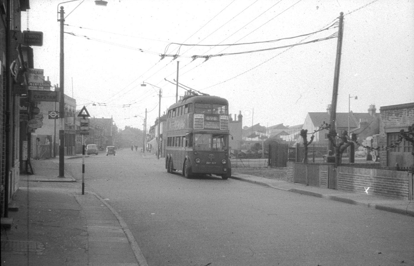
[Picture 405 was taken in early 1959 but the road sign for the level crossing of this narrow gauge railway was still in
place two years after the rail service ceased].
From: "John King" <JKing77189@aol.com>
Until the GLC and Greater London Boroughs were formed in April 1965 Erith Urban District Council
was in the administrative county of Kent. Nearby Abbey Wood was in the Metropolitan Borough of Woolwich.
After this date Erith, Crayford and Bexley became The London Borough of Bexley. Woolwich and Greenwich became the
London Borough of Greenwich.
As a footnote, before the formation of the LCC in 1889 both Woolwich and Greenwich were also in Kent.
From: "Kenneth Chamberlain" <kenneth@chamberlain2.fsnet.co.uk>
Having only recently acquired Broadband I have now the opportunity to access sites such as yours.
I was absolutely delighted to read of the amount of interest there is in the "Sand Pits" at Erith. My father worked there for 40 years and
I worked there for a few years. I have quite a large collection of photos of the site which I inherited from the former Manager. In fact I now give
an illustrated lecture on the site and it's workings. There are very few of the former employees now alive, but those of us who are meet
occasionally and we reminisce.
The pit was always known as "Parish's" but in fact the business was sold in 1932 and became Talbot Estates and remained so until it ceased
trading in C 1970. It is now a landfill site, awaiting development.
Delighted to hear from any one with an interest.