Mystery Location
Wandsworth SW18, at the junction of Putney Bridge Road and Armoury Way
|
|
| Enlarged version not available. © 2004 TLRS |
From: "John Prentice" <john.prentice@tramways.freeserve.co.uk>
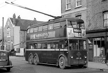
Here is a picture of 1063 on route 655. It is one of the negatives by the late W.J.Haynes which
the TLRS now owns.
Recently it was used in
Capital Transport's London Trolleybus Volume 2
where the author, Ken Blacker says it is in Brentford. However, extremely limited records of Bill Haynes suggests that
it is in Putney, probably Putney Bridge Road.
Which is correct?
![]()
17 researchers have so far offered their opinion. Thank you all for your comments.
From: "Chris Veasey" <veaseys@nildram.co.uk>
Looks more Brentfordish than Putneyish, but may be tricky as much of Brentford has changed beyond recognition since that time. I'll see about looking into it.
From: "Terry Russell" <terry@terryrusselltrams.wanadoo.co.uk>
I am afraid I do not know the area at all David and so cannot help. There is a shot in the same book with B1's going for scrap with a 630 with poles down and I do not know where that is either.
From: "Alan Pearmain" <alan.pearmain@lineone.net>
I can't help with the exact location, but some observations:
The narrowness of the road, together with the marked parking place, suggests a side road, probably just off a
major road. The angle of the poles and what little we can see of the wires suggests that they are more or
less over the centre of the road. It's hard to see whether the driver is actually in the cab, or if that's
just his jacket hanging in the corner; however, it looks as if one of the crew [wearing a peaked cap] is
taking his ease on one of the rear bench seats, so the bus is probably standing at a terminus formed by a
one way loop around some back roads.
Even fifty or so years later, there's a good chance that the church or chapel will still be there [although it
may no longer be used as such, and would therefore not appear on maps]; but a quick look at the Putney street
map gives no obvious possibilities. A more detailed examination of the route might help, especially if there
any known turning points. An route extracted from the 1946 edition of the Trolleybus & Tram Routes map is
shown here.
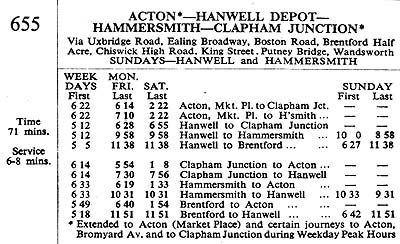 |
![]() Click on the red square for a 655 Route Map.
Click on the red square for a 655 Route Map.
The destination blind shows "Clapham Junction", and it is the common practice for bus
crew to change the blinds immediately on arrival at a terminus. The timetable shows possible routings as
"Acton - Clapham Junction" and "Hanwell - Clapham Junction". This suggests that the bus is
standing either at Acton or Hanwell: the latter seems more likely, as it appears the 655 was the only service
to terminate there; as far as we can see there is not even a marked bus stand. This supposes that there were no
other unlisted turning points.
So, what are the possible locations? Going by churches marked on the street map, Hanwell seems to offer three
possibilities: Church Street; St George's Road; and Westminster Road. Acton has Crown Street, Church Road and
just possibly Berrymead Gardens. If the church is no longer in use, there may be others.
I do not know the area at all, and can offer no other suggestions. It appears that
Hanwell Methodist Church in
Church Road was rebuilt in 2003, so that could make identification difficult. Good luck to whoever goes looking.
From: From: "Keith H" <keith@s-19.wanadoo.co.uk>
Hmm, not sure about this one, looks like Putney in the background to me though.
From: "Christopher Ramsay" <christopher.ramsay@btinternet.com>
No the picture is definitely not St Georges Southall nor any other Anglican church in Southall.
Christopher Ramsay Vicar
From: "Geoff Bannister" <Gbannister10@aol.com>
I had a careful look at this, since I knew Putney Bridge Road well for many years. I then had a
long phone discussion with one of my oldest friends; we were trolley fanatics together in the 50s and he has a copy
of the book and we are both of the opinion that it is not Putney Bridge Road so the Brentford location seems more
likely.
I used to travel to college in Isleworth in the late 1950s/early 1960s but my memories of the trolley route are
vague; I would be inclined to plump for the stretch between Brentford and Kew Bridge but that is a calculated guess.
From: "Marratxi" <Marratxi@BazzaSoft.freeserve.co.uk>
Boston Manor Road, Hanwell?
From: "Colin Vaughan" <niloc99@btinternet.com>
My first reaction was, what is a 'K' class doing in service on route 655? The scene appears to be
pre-war, because the one traction pole appears to be repleasant in new paint, and as far as I can see, does not
have white bands at the bottom, as these bands were painted well up the pole, I would have thought that some trace would
show through the windows of the pre war Austin facing in the opposite direction. If it was wartime, then the Austin
would have had a 'gas bag' on the roof, and the Trolley would probably have anti-blast screening on the widows, so this
'K' is probably brand new in 1938/39.
Reference shows that 'K's were initially delivered to Fulwell Depot, but most were destined for Edmonton, to run on
the North London routes, my neck of the woods now ie: Enfield / Winchmore Hill / Waltham Cross etc. The bold style
of the destination blinds also indicates prewar origin.
My guess is that it is indeed Brentford, the slight left hand curve of the road would indicate its on the A3002, the
'K' is facing south, just North of Brentford Half-Acre. Maybe Hanwell borrowed one or two for test running, prior to the
departure to North London, Sunday working maybe, as the road scene looks like a quiet Sunday Afternoon, late in the year.
From: "Andrew O'Brien" <andrew@obrien9855.freeserve.co.uk>
I would opt for Putney Bridge Road, as I do not associate the building at the rear of the bus with Brentford, however I did not know that the 655 ever went as far as Putney? Clapham Jnc. is on the destination panel. so it could have passed through Putney, just a little before my time I think.
From: "Geoff Bannister" <Gbannister10@aol.com>
I've been putting my mind a little further to points raised in the discussion of the location of 1063 and thought I would throw the following odds and ends into the mixture.
Hope these ramblings will prove of use.
From: "Chris Cook" <c.cook@btinternet.com>
Sorry I am unable to place that 655 for you. The best hope must be the church or chapel in the
background with its distinctive chimney.
However, I am most impressed with the level of thought that's gone into locating the scene, so far. A weekend touring
suburban churches is obviously called for. I don't suppose the photo is accessible in a larger version?
From: "Colin Rosenstiel" <rosenstiel@cix.co.uk>
Following the discussion here, I could believe it was Putney Bridge Road, approaching Putney High
Street from Wandsworth. The side road behind the bus would be Burstock Road.
That is not consistent with the destination blind, however. It would be going to Acton if I'm right.
From: "Dave Seddon" <Dave@seddon99.freeserve.co.uk>
I used to live in the Hanwell area and rode on this route many times. It is definitely not in
Jessamine Road as this particular street was purely residential. As a guess the location could be somewhere along
Brentford High Street, perhaps opposite the gas works.
I expect you will know much better than I, but when these vehicles were delivered did they not have silver painted
roofs which were later painted brown on the outbreak of WW2? If this is the case, then perhaps the photo could
have been taken sometime between the end of the war and about 1950 when all trolleybuses were fitted to display
standard garage codes.
Colin Vaughn expresses some surprise that the vehicle is a 'K' class instead of the usual 'F1', saying that this
class mainly operated in North London. This is of course true but didn't some also work out of Hammersmith - I wonder
if any ever found their way onto the 655, especially as the Clapham Junction bound vehicles would have passed right
outside that depot?
Whilst obviously not relevant to this discussion, although Hanwell vehicles were usually 'F1s' or 'Q1s', during the
last months of operation there some 'K' and even 'H' class vehicles were operated.
Out of curiosity, can you explain why a 'Q' class was transferred from Fulwell for 24 hours or so just to be the
last Hanwell trolleybus when there were already members of this class operating from there?
From: "John King" <JKing77189@aol.com>
I have just had another look at you mystery location after looking at the original photograph in
The London Trolleybus volume two book. Your photograph misses one important piece of evidence which is shown in the
book.
Next to the hairdressers is a cafe. Just the sort of thing to find at a bus terminus. The cafe is called the Crown Cafe.
Alan Pearmain in his piece offers Crown Street, Acton as one of the possibilities with a church. Crown Street,
Crown Cafe. coincidence.
If someone has access to a local business directory of around the date of the picture perhaps they could confirm the
road has a cafe, church, and hairdresser.
;) From: "Martin Eady" <martin.eady@btinternet.com>
From: "Martin Eady" <martin.eady@btinternet.com>
I have established the location of this shot. It's not Acton, Hanwell or Brentford, so it was
logical to look somewhere between Hammersmith and Clapham Junction. If Bill Haynes notes indicated Putney Bridge
Road, that was a good place to start. It is in Wandsworth SW18, at the junction of Putney Bridge Road and Armoury Way.
This is now part of the Wandsworth one-way system - possibly Armoury Way was not called that in trolleybus days.
The church is now the "Edwardian Fireplace Company", the shop behind the trolleybus is a tattoo studio and
the other shop front is now a private dwelling. The accompanying photo was taken on 12th June 2005
From: "Geoff Bannister" <Gbannister10@aol.com>
I have to admit that I was surprised that this turned out to be Putney Bridge Road. Having lived
within a mile or so of this location for over 40 years, it did not seem familiar to me. On reflection, I think this
is because the trolleybus is blocking the view of the building on the corner.
I would query with our informant as to whether that is Armoury Way in the background or the corner of Frogmore. I seem
to recall the entry to the former being wider.
If I might digress onto the question of Armoury Way and the one-way system, this road was a new road built in the late
1930s to act as a relief to Wandsworth High Street, allowing traffic from Putney towards Battersea [and vice versa] to
take a more direct line and was always known by this name. If anyone reading this has a copy of Robert Harley's
"Wandsworth and Battersea Tramways", photo no.85 shows the position where Armoury Way was to meet York Road
behind the advertisement hoardings in the left background.
In an attempt to reduce traffic congestion, the right turn from Wandsworth High Street into Garratt Lane was banned
in [I think] late 1959 except for the trolleybuses. There is a picture on p.41 of Hugh Taylor's "London Trolleybus
;) Routes" showing the set-up. This continued after the conversion for a while with the 220 service until the full
one-way system was introduced "for an experimental period of six months" - a period which has now lasted
approximately 44 years!
Routes" showing the set-up. This continued after the conversion for a while with the 220 service until the full
one-way system was introduced "for an experimental period of six months" - a period which has now lasted
approximately 44 years!
From: "Professor" <profess@gmx.co.uk>
I work with someone who is into trolley buses.
He pointed out that this was Putney Bridge Road IMMEDIATELY. Although I have lived ON Frogmore since 1985 I could not
see where the original picture was taken. However, after seeing the second picture [up to date] I was able to
see straight away that this was the place.
I have attached a map of the area where the picture of Putney Bridge Road was taken. It is definitely the beginning of
Putney Bridge Road. Police cars come out at the back of station and straight down onto Armoury Way.
From: "Brian Watkinson" <camberfarm@sfr.fr>
I have sent this before re the 655 picture at Wandsworth High Street, seemed never to have been received despite passing security!
That is not a church on the corner of Armoury Way behind the bus, it is (was) a school and the first school I went to in 1953! It was All Saints C of E school.
Armoury Way was two way in those days and we turned out in June to see the Queen drive past on her way to the Derby at Epsom.
Cheers, Brian Watkinson
;)
;)